Simulating Snowmelt Rate, Timing, and Amount to Disentangle Controls on Runoff Production Across the Western United States
[2014- present]
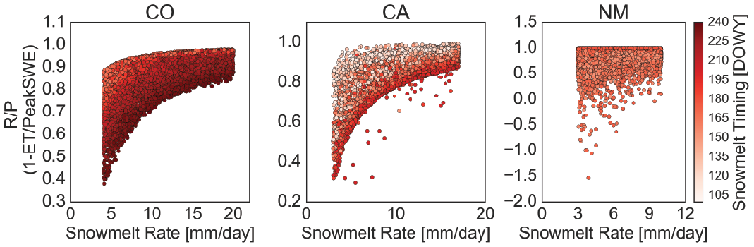
Snowmelt rate, timing, and amount are all tightly coupled in natural systems; large snowpacks tend to melt later in the year and more rapidly while locations with small snowpacks tend to melt earlier in the year and more slowly. This project uses snowmelt scenarios and the Regional Hydro-ecologic Simulation System to experimentally remove the collinearity between snowmelt rate, timing, and amount at three locations across the western United States to better assess how changes in snowmelt rate, timing, and amount influence runoff production.
Streamflow Production Sensitivity to Snowmelt Across Colorado’s Trans-basin Diversions
[2013 - present]
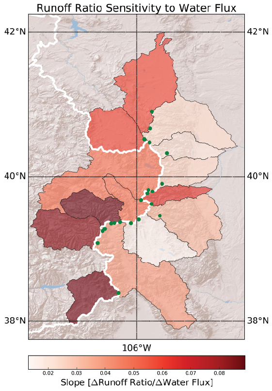
In Colorado, water is moved across the continental divide from the western slope of the Rocky Mountains to the east side of the divide to augment water resources. This project investigated how sensitive streamflow was to a change in snowmelt in basins on either side of these trans-basin diversions. Greater sensitivity in the basins receiving water from the western slope may indicate that greater diversion will be necessary in the future while greater sensitivity on the western side of the divide indicate that the tran-basin diversion may need to be decreased to satisfy downstream water rights. Work using large-scale hydrologic models such as VIC and WRF show that streamflow in basins contributing to trans-basin diversions are more sensitive to a unit change in water flux (snowmelt plus rainfall). This suggests that, although streamflow will decline as snowpack declines on either side of the continental divide, streamflow will decline more rapidly on the western slope of the divide.
Snowmelt Rate and Climate-corrected Streamflow Production Across the Western United States
[2013-2016]
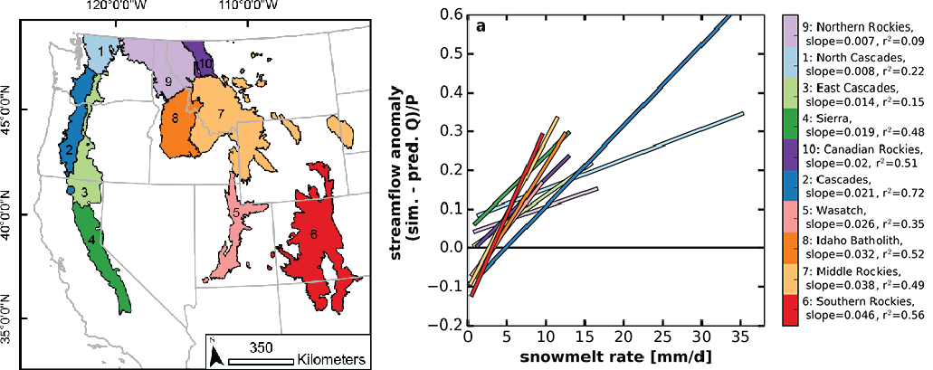
Declining mountain snowpack and earlier snowmelt across the western United States has implications for downstream communities. We present a possible mechanism linking snowmelt rate and streamflow generation using a gridded implementation of the Budyko framework. We computed an ensemble of Budyko streamflow anomalies (BSAs) using Variable Infiltration Capacity model-simulated evapotranspiration, potential evapotranspiration, and estimated precipitation at 1/16° resolution from 1950 to 2013. BSA was correlated with simulated baseflow efficiency (r2 = 0.64) and simulated snowmelt rate (r2 = 0.42). The strong correlation between snowmelt rate and baseflow efficiency (r2 = 0.73) links these relationships and supports a possible streamflow generation mechanism wherein greater snowmelt rates increase subsurface flow. Rapid snowmelt may thus bring the soil to field capacity, facilitating below-root zone percolation, streamflow, and a positive BSA. Previous works have shown that future increases in regional air temperature may lead to earlier, slower snowmelt and hence decreased streamflow production via the mechanism proposed by this work.
Check out this paper for more information on this project.
Thermokarst Headwall Dynamics, Selawik Retrogressive Thaw Slump, Alaska
[2011 - 2013]
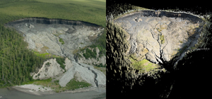
My MS focused on working to understand how hydrologic and meteorologic drivers control the growth of a retrogressive thaw slump in northwest Alaska. The Selawik slump initiated in 2004 and has been growing 7-20 m/yr since. I use ground based LiDAR to take high resolution topographic surveys of the feature twice a day and use those data sets to investigate changes in the rate of the feature’s growth and morphology. Retrogressive thaw slumps are a type of thermokarst feature with the ability to mobilize large quantities of sediment and nutrients to downstream environments. Better understanding what drives this feature’s growth will inform how these features will behave under different climate warming scenarios. For more information check out my paper and thesis on this project.
Post-Wildfire Erosion, Bryce Canyon NP, Utah
[Summer 2010]
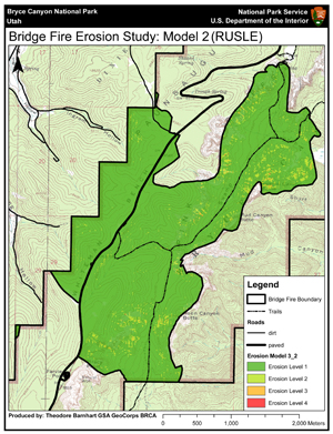
As part of a GSA GeoCorps position at Bryce Canyon National Park, Utah I designed and implemented a post-wildfire erosion study at a recent burn within the Park. The project was the start of broader work to investigate if the scenic amphitheaters at Bryce Canyon NP could have been initiated by large disturbance events such as wildfires. I initially mapped and modelled erosion throughout the burned study area. I then proposed a second phase of the study installing sediment fences to better quantify the amount of erosion at the hillslope scale. Sediment fences were installed before the summer convective storm season. In the fall, the sediment fences were emptied and weighed.
Glaciomarine Sediment Flux and Transportation Mechanisms, Kronerbreen/Kongsvegan, Kongsfjorden, Svalbard
[Summer 2009]
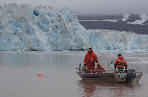
I had the good fortune to participate in the NSF Svalbard REU program working on understanding how tidewater glaciers are responding to contemporary climate change. My project used sediment traps deployed in one of the meltwater plumes from a tidewater glacial complex to investigate changes in sedimentation rates and sediment transportation mechanisms in the water column. This work was used for my senior honors thesis at Whitman College.
Vegetation Change as a Metric for Wetland Restoration Success, San Bernardino Cienaga, Sonora, Mexico
[2008-2009]
As a portion of the ecology unit on Whitman College’s 2008 Semester in the West program I visited a wetland restoration project on the San Bernardino Ranch in Sonora Mexico. I organized and mapped vegetation survey data collected over six years to investigate if vegetation changes in the wetland could be used as a metric for wetland restoration success.